What Is LiDAR Technology and How It’s Changing Modern Surveying
What Is LiDAR Technology and How It’s Changing Modern Surveying
If you work in construction, architecture, or engineering, you have probably heard the term “LiDAR” more than a few times recently. And for good reason. This technology is rewriting how surveyors capture the physical world, turning hours of manual fieldwork into precise digital models in a fraction of the time.
Here is a plain-language breakdown of what LiDAR technology actually is, how it works, where it’s being used, and why it matters for your next project.
What Is LiDAR Technology?
LiDAR stands for Light Detection and Ranging. At its core, it works by firing rapid laser pulses at a surface and measuring how long it takes for those pulses to bounce back to the sensor. Repeat that process millions of times per second, and you end up with a dense collection of 3D data points called a point cloud.
Think of it like sonar, but using light instead of sound. The sensor “sees” everything around it, recording exact positions in three-dimensional space with millimetre-level accuracy.
A standard LiDAR instrument includes three components: a laser source, a scanner to direct the pulses, and a GPS/GNSS receiver to georeference every data point. These three parts work together to produce spatial coordinates (latitude, longitude, and elevation) for each point captured.
Let’s break it down even further.
How Does a LiDAR Survey Work?
Here is the basic workflow:
- Data capture — The LiDAR sensor fires laser pulses and records the return time for each. This happens at speeds of hundreds of thousands to millions of pulses per second.
- Point cloud generation — The collected return data forms a dense 3D point cloud representing the scanned surface or structure.
- Processing — Software filters the point cloud, removes noise, and classifies points by type (ground, vegetation, structures, etc.).
- Modelling — Processed data feeds into deliverables like digital terrain models (DTMs), digital elevation models (DEMs), 3D BIM models, or topographic maps.
The whole cycle, from scan to usable model, is far faster than traditional ground-based surveying methods. LiDAR accelerates data acquisition compared to traditional surveying methods, allowing large areas to be covered in a fraction of the time required by ground-based approaches.
Types of LiDAR Systems Used in Surveying
Not all LiDAR setups are the same. The platform and configuration depend on the project type and scale.
Airborne LiDAR mounts on aircraft, helicopters, or drones and covers large areas quickly. Whether mounted on an airborne system or a mobile platform on ground vehicles, LiDAR sensors provide millimetre-scale vertical accuracy. Airborne systems work well for topographic mapping, corridor mapping, and flood risk modelling.
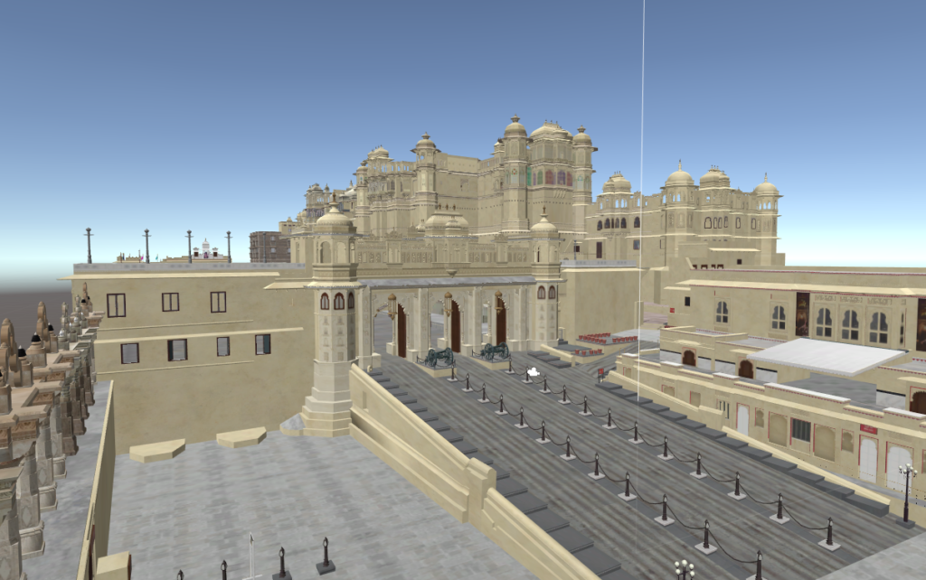
Terrestrial LiDAR (TLS) places the scanner on a tripod at ground level. Surveyors capture detailed 3D data of structures, façades, interiors, and complex geometry. This method suits architectural surveys, heritage documentation, and as-built documentation.
Mobile LiDAR mounts the scanner on a vehicle for road surveys, railway mapping, and utility corridor mapping. The system captures data continuously while the vehicle moves, covering kilometres of infrastructure per hour.
UAV (drone-mounted) LiDAR combines the flexibility of drones with the precision of laser scanning. UAVs equipped with LiDAR provide a flexible solution for agriculture, mining, and forestry industries, offering detailed aerial surveys with minimal human intervention.
Each type serves a purpose. Choosing the right one comes down to site conditions, required accuracy, budget, and project scope.
LiDAR Accuracy: What the Numbers Say
One of the strongest arguments for LiDAR over traditional methods is raw accuracy.
LiDAR delivers centimetre-level accuracy, providing a detailed and reliable representation of the Earth’s surface, which is helpful for topographic mapping, volumetric calculations, and infrastructure design.
At the higher end of the technology, coherent Doppler LiDAR systems now deliver measurement precision better than 0.8 centimetres per second for velocity and 0.8 metres for range, while several manufacturers have announced technologies that achieve 99.9% accuracy in object tracking.
For indoor environments, independent academic research has found impressive results too. Studies examining iPad Pro LiDAR sensors found planar segment accuracy of 5.3 mm in 3D modelling of rooms, with most LiDAR points falling within 10 cm of terrestrial laser scanner reference models.
These numbers put LiDAR well ahead of manual measurement techniques for projects where accuracy is non-negotiable.
Where Is LiDAR Being Used Today?
LiDAR technology now appears across a wide range of industries. Here are the main areas where it’s making a direct difference.
Architecture, Engineering, and Construction (AEC)
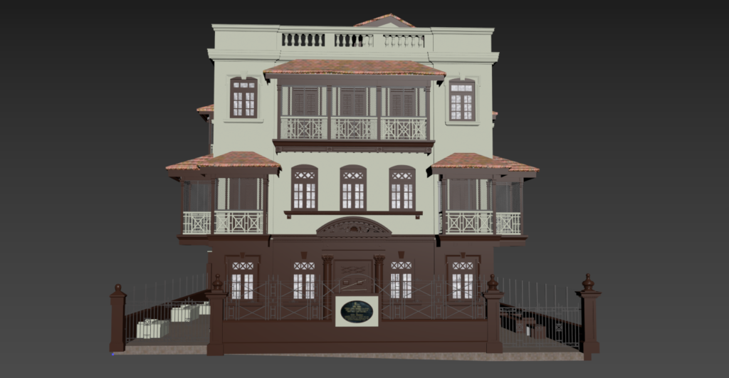
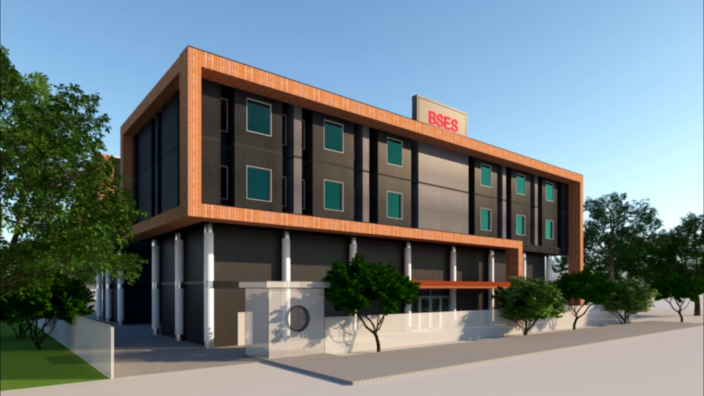
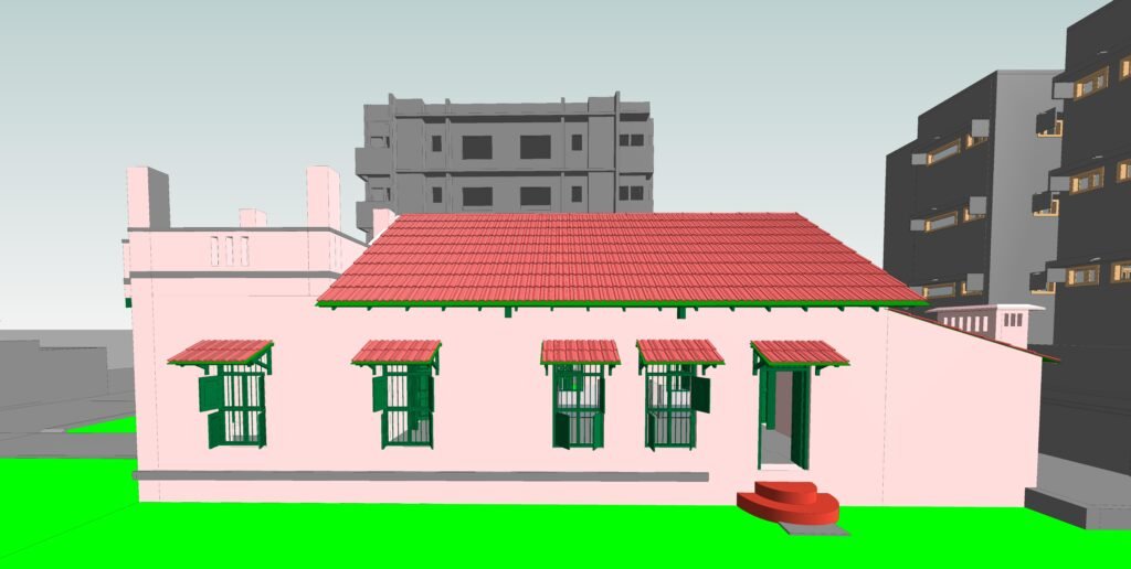
LiDAR has become a go-to tool for as-built documentation. Surveyors scan existing structures to create accurate 3D models that feed directly into BIM (Building Information Modelling) workflows. This process, often called Scan to BIM, reduces costly measurement errors before construction begins.
Teams like those at Shayona Tech use 3D LiDAR scanning specifically for this purpose, capturing point cloud data from existing buildings and converting it into intelligent BIM models for architecture, engineering, and construction projects.
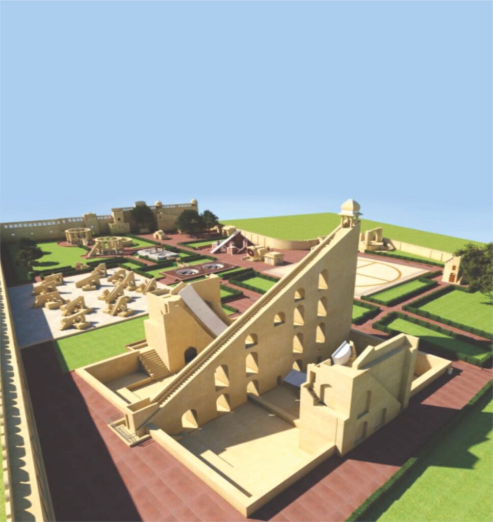
Heritage Conservation and Archaeology
LiDAR can penetrate through vegetation, revealing hidden features such as water bodies, geological formations, and archaeological sites, which enables more informed decision-making and reduces the risk of unforeseen challenges during project development.
This penetration ability has been used to discover ancient ruins, buried structures, and landscape features invisible to aerial photography.
Infrastructure and Corridor Mapping
Governments and utility companies use LiDAR extensively for road surveys, power line inspection, rail corridor mapping, and pipeline routing. Airborne and mobile LiDAR systems provide high-resolution, georeferenced data for route planning, maintenance, and expansion projects, with governments and utility companies relying on LiDAR for right-of-way management, vegetation analysis, and hazard detection.
Environmental Monitoring and Flood Risk
The Federal Highway Administration’s 3D Elevation Program, coordinated with the USGS, noted that high-resolution elevation data can generate USD 690 million in annual conservative benefits nationwide, supporting flood risk mitigation, construction planning, and precision agriculture.
That figure alone tells you how much value accurate elevation data carries at a national scale.
Agriculture and Forestry
LiDAR is positioning itself as one of the most practical non-destructive methods to collect accurate information on ground crop fields, allowing measurement of yield estimations, aboveground biomass, vegetation indices, and plant phenotyping.
Drone-mounted LiDAR surveys agricultural plots and forest stands far faster than ground crews can manage on foot.
Smart Cities and Urban Planning
City planners use LiDAR-derived 3D maps to model traffic flows, design infrastructure, and assess building shadows. Government agencies, municipalities, and construction firms are deploying LiDAR-based mapping solutions for terrain modelling, flood risk assessment, and structural monitoring as part of smart city planning.
LiDAR vs. Traditional Surveying Methods
Here is a direct comparison to put things in perspective:
| Factor | Traditional Surveying | LiDAR Scanning |
| Speed | Hours to days per site | Minutes to hours per site |
| Data density | Sparse point measurements | Millions of points per second |
| Accuracy | Dependent on operator | Millimetre to centimetre precision |
| Vegetation penetration | Limited | Yes (multiple return pulses) |
| Risk (hazardous areas) | Surveyor must enter site | Remote capture possible |
| Output | 2D plans, manual notes | 3D point clouds, BIM-ready models |
LiDAR systems collect millions of data points per second, allowing surveyors to cover large areas efficiently, which is particularly valuable for mapping entire urban areas or massive infrastructure projects.
Traditional total station surveys still have their place for small boundary surveys or legal demarcation work. For anything involving existing structures, large sites, or complex 3D geometry, LiDAR wins on speed, safety, and detail.
The LiDAR Market: Where Things Stand Right Now
The numbers behind LiDAR adoption tell a clear story.
The global LiDAR market was estimated at USD 2.74 billion in 2024 and is projected to reach USD 4.71 billion by 2030, growing at a CAGR of 9.5% from 2025 to 2030.
In the United States specifically, the LiDAR market was estimated at USD 679.4 million in 2024 and is expected to grow at a CAGR of 23.9% from 2025 to 2030, driven by increasing demand for high-precision mapping in construction, agriculture, and transportation.
The LiDAR market is projected to reach USD 12.79 billion by 2030 from USD 3.27 billion in 2025, with government initiatives supporting smart city development and investments in digital twin and 3D mapping technologies fuelling demand.
The growth reflects adoption across industries, not just surveying. Autonomous vehicles, defence, agriculture, and coastal monitoring all pull from the same technology base.
Challenges Worth Knowing About
LiDAR is not without its limitations. Being clear about these helps you plan projects properly.
Weather sensitivity. Certain weather conditions, like rain, fog, or high winds, can scatter or absorb laser pulses, reducing the accuracy and completeness of captured data. Scheduling surveys around forecast conditions matters.
Processing demands. Point clouds are large data sets. Processing and storing them requires solid IT infrastructure and skilled operators who understand the software.
Upfront cost. High-end LiDAR instruments and the software to process their output carry a real price tag. This is less of a barrier for larger projects where the time savings justify the investment, but smaller jobs may not always warrant full-scale LiDAR deployment.
Skilled personnel. The equipment is only as good as the people running it. Operators need to understand sensor placement, scan overlap, GPS accuracy requirements, and post-processing workflows.
How Shayona Tech Applies LiDAR in Practice
Shayona Tech, based in Ahmedabad, India, focuses specifically on 3D LiDAR scanning and Scan to BIM services for the AEC sector, infrastructure, and heritage conservation. Founded in 2012, the team works with point cloud data to produce accurate 3D models that meet global project standards.
Their services cover drone UAV surveys, terrestrial laser scanning, Scan to BIM modelling, and AR/VR visualization, all built on the foundation of precise LiDAR data capture.
For teams looking to move from manual as-built measurements to accurate digital models, Shayona Tech’s workflow connects the physical scan directly to BIM-ready outputs.
Also learn about – Scan to BIM Explained: Benefits, Process and Real-World Use Cases
What to Look for in a LiDAR Survey Provider
If you are evaluating LiDAR survey partners for an upcoming project, here are the questions worth asking:
- What scanner hardware do they use, and what accuracy specifications does it carry?
- Do they have experience with your project type (heritage, infrastructure, new construction)?
- How do they handle point cloud registration and quality checks?
- What file formats do they deliver, and do those formats work with your BIM software?
- Do they carry professional indemnity and the relevant survey certifications?
Getting clear answers to these questions early saves time during delivery.
FAQs About LiDAR Technology in Surveying
Q1: What is the difference between LiDAR and photogrammetry?
LiDAR uses active laser pulses to directly measure distances, so it works in low-light conditions and can penetrate vegetation to reach the ground beneath. Photogrammetry relies on overlapping photographs and struggles in dense vegetation or poor lighting. For high-accuracy structural surveys and terrain mapping, LiDAR generally produces more reliable results.
Q2: How accurate is a LiDAR survey for construction projects?
Modern LiDAR systems deliver centimetre-level accuracy, with some high-end instruments achieving sub-centimetre precision. For Scan to BIM work, this means your 3D model reflects the actual geometry of the existing structure with minimal error, reducing surprises during design and construction.
Q3: Can LiDAR scanning be used for heritage building documentation?
Yes, and it is one of the strongest use cases. Terrestrial LiDAR captures every surface detail of historic structures without physical contact. The resulting point cloud and 3D model serve as a permanent digital record for conservation planning, restoration work, and structural analysis.
Q4: How long does a LiDAR survey typically take?
It depends on site size and complexity. A single building floor might take a few hours of scanning. A large industrial complex or urban block could take a full day. Processing the point cloud into usable deliverables usually takes additional time, depending on the level of detail required.
Q5: Is LiDAR scanning only for large projects, or can smaller sites benefit too?
LiDAR works at any scale. Smaller projects benefit from faster data capture, reduced site access time, and a permanent 3D record that avoids costly return visits. The technology has become more accessible as hardware costs have dropped, making it practical for medium-scale renovation, infrastructure inspection, and interior documentation projects.