
SCAN TO BIM
- 3D LiDAR Scanning
- Drone/UAV Survey
- Mobile Mapping
- Orthophotos
- Geographic Information System (GIS) Mapping
- Ground Penetrating Radar (GPR)
- Non-Destructive Testing (NDT)
- LiDAR Data Processing
- 3D CAD Modelling
- 3D BIM Modelling
- CAD TO BIM
- SCAN TO BIM
- As-built Modelling
- 3D MESH Model
- Plant Modeling
- Smart City Modeling
- Digital Twin Modeling Services
- Reverse Engineering
- Infrastructure Assessment
- Stockpile Volume Calculation
- Heritage Conservation
- MR/XR Experiences
- Virtual Reality (VR) & Augmented Reality (AR)
- Virtual Events with 360 Degree Coverage
- Project Based Training
Scan to BIM Services in India | 3D LiDAR Scan to BIM Modelling - Shayona Tech
Turning Real-World Structures Into Intelligent BIM Models
When you’re renovating a building, retrofitting an industrial plant, or managing a large facility, one thing holds back good decision-making more than anything else: inaccurate as-built information. Old drawings don’t match what’s on site. Manual measurements miss critical details. And working from incomplete data means design conflicts, costly rework, and delays you didn’t budget for.
Scan to BIM services solve this at the root. By combining high-accuracy 3D LiDAR scanning with structured Building Information Modeling, Shayona Tech captures the precise as-built condition of any structure and converts it into a data-rich, fully usable BIM model ready for your design, construction, or facility management workflow.
If you need scan to BIM services in India that go beyond a basic point cloud handoff, you’re in the right place.
What Is Scan to BIM?
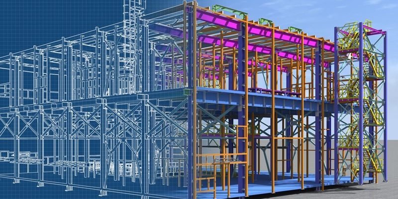
Scan to BIM is the process of using 3D LiDAR scanning technology to capture the physical geometry of a structure and then converting that scan data into a parametric BIM model inside platforms like Autodesk Revit.
Here’s the straightforward version of how it works:
A LiDAR scanner fires millions of precise pulses at surfaces across the building. Each pulse returns with x, y, z coordinate data. The combined result called a point cloud is an extraordinarily dense, millimeter-accurate three-dimensional picture of the space as it actually exists. That point cloud becomes the reference layer on top of which a BIM modeler builds intelligent, structured components: walls, columns, floors, beams, doors, windows, and MEP systems, each carrying properties beyond just shape.
The final output isn’t just a 3D picture. It’s a model you can query, analyze, coordinate, and build from.
Our Scan to BIM Services at Shayona Tech
Architectural Scan to BIM Service
For architects working on renovation, extension, or adaptive reuse projects, accurate as-built documentation is the foundation everything else rests on. Our architectural scan to BIM service captures the precise geometry of existing buildings floor plans, ceiling heights, wall thicknesses, openings, and facade details and models it in Revit at the LOD your project requires.
The result is a clean, coordinated Revit model you can design from with confidence, rather than retrofitting assumptions made from outdated drawings.
Structural Scan to BIM
Structural documentation for existing buildings presents a particular challenge: load-bearing elements are often hidden, inaccessible, or poorly documented in older drawings. Our structural scan to BIM workflow captures columns, beams, slabs, and connections with high geometric accuracy, giving structural engineers a reliable base for analysis, reinforcement planning, and renovation design.
MEP Scan to BIM
Oil, Gas, and Industrial Facilities
Mechanical, electrical, and plumbing systems in existing buildings are some of the hardest things to document accurately by hand. Our MEP scan to BIM service models all existing services ductwork, pipework, cable trays, electrical panels, and equipment at LOD 300 or higher. This is especially valuable for clash detection and coordination in retrofit and refurbishment projects where new MEP systems need to co-exist with what’s already installed.
3D LiDAR Scan to BIM for Industrial Facilities
Factories, refineries, power plants, and processing facilities are among the most complex environments to document. Our 3D LiDAR scan to BIM workflow handles dense pipe runs, elevated steel structures, large plant equipment, and multi-level access systems. We deliver coordinated plant models that support maintenance planning, brownfield design, and digital twin development.
Scan to BIM for Infrastructure and Civil Projects
Beyond buildings, BIM is increasingly used for infrastructure assets bridges, tunnels, highways, and rail corridors. Our 3D LiDAR scanning to BIM services extend to civil infrastructure, delivering accurate spatial data in IFC-compatible formats suitable for OpenBIM workflows and infrastructure information modeling.
Heritage and Conservation Scan to BIM
Documenting historic structures requires a non-invasive, contact-free approach. Our heritage scan to BIM service creates accurate digital records of complex, irregular geometry found in older buildings arched ceilings, ornate facades, non-standard wall profiles where traditional measurement methods fall short. These models serve as a basis for conservation work, digital archiving, and adaptive reuse design.
Why Scan to BIM Outperforms Traditional As-Built Methods
Most teams still rely on manual measurement and re-drafting when they need existing building documentation. This is slow, expensive, and introduces measurement error at every step. Here’s how the two approaches stack up:
Factor
- Accuracy
- Time on site
- Coverage of complex geometry
- Clash detection capability
- Output formats
- Re-usability of data
- Risk of errors propagating
Manual As-Built Survey
- ±10–50mm typical
- Days to weeks
- Limited, prone to gaps
- Poor without 3D model
- 2D drawings only
- Low
- High
Scan to BIM
- ±2–5mm consistently
- Hours
- Complete, high-density capture
- Full clash detection in Revit
- Revit, IFC, DWG, point cloud
- High reused across project lifecycle
- Minimal
| Factor | Manual As-Built Survey | Scan to BIM |
|---|---|---|
| Accuracy | ✔±10–50mm typical | ✔±2–5mm consistently |
| Time on site | ✔Days to weeks | ✔Hours |
| Coverage of complex geometry | ✔Limited, prone to gaps | ✔Complete, high-density capture |
| Clash detection capability | ✔Poor without 3D model | ✔Full clash detection in Revit |
| Output formats | ✔2D drawings only | ✔Revit, IFC, DWG, point cloud |
| Re-usability of data | ✔Low | ✔High reused across project lifecycle |
| Risk of errors propagating | ✔High | ✔Minimal |
The difference isn’t marginal. On complex renovation projects, teams that start from a scan-based BIM model consistently report fewer design surprises on site and significantly reduced rework costs compared to those who work from manually measured drawings.
Industries Shayona Tech Serves with Scan to BIM
Architecture, Engineering, and Construction (AEC)
Architects and project developers use scan to BIM to replace outdated record drawings with verified as-built models before starting design work. Engineers use the models for structural analysis, coordination, and construction documentation. Contractors use them for prefabrication planning and clash detection.
Facility Management
Building owners and facility managers increasingly need accurate digital models for operations planning, space management, and maintenance scheduling. A scan-derived BIM model provides a reliable base for computerized maintenance management systems (CMMS) integration and long-term asset management.
Oil, Gas, and Process Industries
Brownfield projects in the oil and gas sector adding new equipment, rerouting pipework, or decommissioning sections of a facility depend on precise knowledge of what’s already there. Our LiDAR scan to BIM services in industrial environments produce coordinated plant models that reduce the risk of costly clashes and design conflicts before fabrication begins.
Real Estate and Interior Design
Developers and interior designers working on commercial fitouts, hotel renovations, or residential upgrades rely on accurate floor plans and section data to plan effectively. Scan to BIM replaces the tape measure and sketch pad with a verified, geometry-accurate model in a fraction of the time.
Government Infrastructure and Smart Cities
Railway stations, airports, government buildings, and public infrastructure increasingly need digital asset records for management, maintenance, and future development planning. India’s push toward smart city development and BIM mandates for public projects makes this one of the fastest-growing applications for scan to BIM services in India.
Healthcare Facilities
Hospital renovations and healthcare facility expansions require detailed knowledge of existing MEP systems medical gas lines, HVAC, electrical before any new work begins. Our scan to BIM process captures this complexity accurately, reducing the risk of service disruptions during construction.
Levels of Development (LOD) We Delive
- LOD 200: Approximate geometry, suitable for feasibility studies, early design decisions, and space planning. Faster to produce, appropriate when exact dimensions are less critical.
- LOD 300 : Precise, geometrically accurate elements. Suitable for design development, construction documentation, and renovation planning. This is the most commonly requested level for architectural and structural work.
- LOD 350 : Adds interface information between systems, including coordination geometry. Used for detailed MEP coordination and clash detection work.
- LOD 400 : Full fabrication-level detail. Used for prefabrication, manufacturing, and detailed construction planning where every component needs to be modeled to exact dimensions and specifications.
We discuss LOD requirements with every client at project scoping stage so the model we deliver is actually matched to what you need not over-modeled (which costs more and adds noise) and not under-modeled (which creates gaps when you need detail).
Our Scan to BIM Process
Step 1 — Project Brief and Scope Definition
Every project begins with a conversation. What’s the building type? What’s the end use of the BIM model? What LOD is required? Which disciplines need to be modeled architecture only, or full MEP coordination? What software platform will you be working in? These decisions shape everything that follows, and getting them right at the start saves time and cost for everyone.
Step 2 — Site Mobilization and 3D LiDAR Scanning
Our field team mobilizes to your site with calibrated, high-accuracy LiDAR scanners. For most building projects we use terrestrial phase-based scanners, which capture complete floor plans, elevations, and sections from multiple scan positions. For larger or outdoor structures, we may combine terrestrial scanning with drone-based LiDAR capture.
Scan positions are planned to ensure complete coverage with adequate overlap between scans no hidden areas, no gaps.
Step 3 — Point Cloud Registration and Quality Check
Back in the office, individual scan positions are registered together into a single unified point cloud using specialist software. This is where the spatial accuracy of the final deliverable is established. We run quality checks at this stage to confirm coverage completeness and verify accuracy against known control points.
Step 4 — Point Cloud to BIM Modelling
Our BIM modelers use the registered point cloud as a spatial reference to build the Revit model. Walls, floors, ceilings, columns, beams, doors, windows, stairs, and MEP components are modeled in accordance with the agreed LOD and project standards. The point cloud is never discarded it remains a reference layer within the project for ongoing verification.
Step 5 — QA/QC and Model Coordination
Before delivery, the model goes through internal quality assurance. We check geometric accuracy against the point cloud, verify that all agreed elements are included, run basic clash checks, and confirm that the model is clean and well-organized for use in your workflow.
Step 6 — Delivery and Handover
We deliver the Revit model along with the registered point cloud in your preferred format. We walk you through the deliverable, explain any modeling decisions, and remain available for questions after handover. For projects with ongoing scanning requirements progress monitoring, phased delivery we can manage that as part of a longer-term engagement.
Software and Output Formats
We work natively in Autodesk Revit and deliver models compatible with the broader BIM ecosystem. Standard deliverables include:
- Revit models (.RVT) at agreed LOD
- IFC files for OpenBIM and non-Autodesk workflows
- Navisworks files (.NWD/.NWC) for clash detection and coordination review
- AutoCAD drawings (.DWG) plans, sections, elevations derived from the BIM model
- Point cloud files (.E57, .RCP/.RCS, .LAS) for reference or further use
- PDF construction documentation if required
If your workflow uses a platform not listed here ArchiCAD, Bentley, Tekla, or others let us know at project brief stage and we’ll confirm compatibility.
DRONE/UAV SURVEY
SHAYONA MANAGEMENT SERVICES PVT LTD (SMSPL) is a prominent and innovative provider of Drone/Unmanned Aerial Vehicle (UAV) services, distinguishing itself in the rapidly evolving field of aerial technology. With a strong foundation in cutting-edge drone technologies and a commitment to delivering exceptional solutions, SMSPL has established itself as a leader in the UAV industry.
Besides this, by integrating a LiDAR sensor onto a drone and utilizing RTK-enhanced GNSS positioning, that ensures centimetre-level accuracy in data collection. It captures detailed elevation information, structures, vegetation, and other features with unmatched precision, while RTK corrections in real-time eliminate positioning errors caused by environmental factors and satellite signal disruptions.
As a dedicated drone services provider, SMSPL offers a wide array of specialized aerial solutions to cater to various industries and sectors. Their expertise extends across fields such as:
Aerial Photography and Videography: Our advanced UAV fleet is equipped with high-resolution cameras and state-of-the-art stabilization systems, allowing them to capture stunning aerial photographs and videos. They excel in producing captivating imagery for industries such as real estate, marketing, tourism, and entertainment.
Photogrammetry Survey: We specialize in capturing high-resolution aerial imagery and transforming it into accurate 3D models, topographic maps, and detailed surveys. Our state-of-the-art drones equipped with advanced cameras and sensors ensure unparalleled data acquisition, enabling industries such as heritage preservation, construction, agriculture, urban planning, and environmental monitoring to make informed decisions with confidence.
Infrastructure Inspection: Our UAV services are pivotal in inspecting critical infrastructure such as power lines, pipelines, bridges, and towers. By conducting aerial inspections, they help detect potential issues, assess structural integrity, and ensure the safety and reliability of vital infrastructure.
Surveying and Mapping: Leveraging cutting-edge Geographic Information System (GIS) technologies, we generate accurate 3D maps and topographic models through aerial surveying. This aids in urban planning, construction site monitoring, and land development projects. Besides this generation of precise DEM, DTM, and DSM datasets, translating real-world landscapes into high-resolution TIFF deliverables for enhanced topographic insights and actionable geospatial analysis.
Industrial Applications: Industries such as mining, oil and gas, and manufacturing benefit from our UAV services for tasks like asset inspection, volumetric measurements, and site monitoring, enhancing operational efficiency and safety.
Data Analytics and Reporting: We provides comprehensive data analysis and reporting services using the information gathered by their drones. This empowers clients with actionable insights and informed decision-making.
CAD TO BIM
SMSPL is a leading provider of CAD to BIM (Computer-Aided Design to Building Information Modelling) services, offering innovative solutions to transform traditional design processes into efficient, intelligent, and data-rich workflows. With a focus on enhancing the construction and architecture industries, XYZ Company specializes in seamlessly converting 2D CAD drawings into detailed and comprehensive 3D BIM models.
Through its CAD to BIM services, we facilitate the transition from static design representations to dynamic, information-rich models that enable collaboration, analysis, and optimization throughout the project lifecycle. Our team of skilled professionals employs advanced software and techniques to accurately translate CAD designs into BIM, incorporating elements such as geometry, materials, spatial relationships, and metadata.
Our commitment to accuracy, precision, and attention to detail ensures that clients receive BIM models that accurately reflect the original CAD designs while introducing the benefits of parametric modelling, data integration, clash detection, and simulation. By harnessing the power of CAD to BIM conversion, we empower architects, engineers, contractors, and stakeholders to make informed decisions, streamline workflows, and enhance the overall project outcome.
SCAN TO BIM
Shayona Management Services Pvt Ltd (SMSPL) is a leading "Scan to BIM modelling" service provider, specializing in transforming physical buildings, structures, and environments into precise and detailed Building Information Models (BIM). Our expertise lies in using cutting-edge technologies such as 3D laser scanning, reality capture, and point cloud processing to capture accurate data from existing structures and convert them into intelligent BIM models.
SMSPL plays a crucial role in the construction and architectural industries by enabling seamless integration of real-world data into the digital design and construction process. They work with a wide range of projects, including residential buildings, commercial complexes, infrastructure, heritage sites, and industrial facilities.
Our team of skilled BIM experts and technicians meticulously process the captured data to create highly detailed and parametric BIM models. These models contain valuable information such as dimensions, materials, systems, and spatial relationships, providing a comprehensive and collaborative platform for architects, engineers, contractors, and other stakeholders to work on a project.
By utilizing state-of-the-art BIM software, SMSPL ensures that their "Scan to BIM modelling" services produce models that are not only visually accurate but also information-rich, facilitating efficient planning, design validation, clash detection, and coordination throughout the project lifecycle.
Furthermore, SMSPL emphasizes collaboration and open communication with their clients, understanding the unique requirements of each project and tailoring their services accordingly. They are committed to delivering projects on time and within budget, enabling clients to make informed decisions, reduce risks, and enhance project outcomes.
With a reputation for excellence in "Scan to BIM modelling" services, SMSPL has become a trusted partner for architecture firms, construction companies, and real estate developers seeking to leverage the power of BIM technology to optimize their projects' design, construction, and maintenance processes. Their dedication to accuracy, innovation, and customer satisfaction makes them a reliable and sought-after service provider in the BIM industry.
REVERSE ENGINEERING
Reverse engineering using LiDAR scanning involves the use of Light Detection and Ranging (LiDAR) technology to capture precise and detailed 3D measurements of an object or environment. LiDAR sensors emit laser pulses and measure the time it takes for the light to bounce back after hitting a surface, creating a point cloud representation of the surroundings.
In the context of reverse engineering, LiDAR scanning allows engineers and designers to analyse and recreate the physical structure of an object or area with exceptional accuracy.
LiDAR-based reverse engineering finds applications in various fields, including architecture, archaeology, product design, urban planning, and civil engineering. It provides a fast and accurate way to recreate physical objects in digital form, enabling innovation, preservation, and enhancement of existing designs.
AS-BUILT MODELLING
SMSPL is a leading "As-built Modelling" service provider, specializing in creating accurate and detailed digital representations of existing structures and environments. Their expertise lies in capturing real-world data through various surveying/LiDAR techniques and transforming it into high-quality 3D models, enabling clients to have a comprehensive record of the as-built condition of their projects.
As an "As-built Modelling" service provider, SMSPL caters to a wide range of industries, including architecture, engineering, construction, facility management, and more. They offer a valuable solution for projects that require precise documentation of existing conditions, such as renovations, refurbishments, retrofitting, and historical preservation.
HERITAGE CONSERVATION
As a Heritage Conservation Service Provider specializing in LiDAR Scanning, we are dedicated to the preservation, documentation, and restoration of our cultural heritage using cutting-edge technology. Our LiDAR scanning services offer a comprehensive and non-invasive approach to capturing historical sites, cultural landmarks, and architectural wonders with unparalleled precision and accuracy.
Key points to highlight in describing our Heritage Conservation Service Provider using LiDAR Scanning:
Advanced LiDAR Technology: We leverage state-of-the-art LiDAR (Light Detection and Ranging) technology, which utilizes laser pulses to measure distances and create highly detailed 3D point clouds of heritage sites. This non-contact, non-destructive technique ensures that the integrity of historical structures is preserved while obtaining the most accurate data possible.
Comprehensive Documentation: Our LiDAR scanning services encompass the meticulous documentation of heritage sites. By capturing intricate details in 3D models and point clouds, we create a digital archive that serves as a valuable resource for research, conservation planning, and public education.
Precise Data Acquisition: Through LiDAR scanning, we obtain precise data, including architectural elements, surface features, and spatial relationships. This information is critical for understanding the historical significance of the site and forms the basis for preservation and restoration efforts.
Non-Invasive Preservation: Our LiDAR scanning approach is non-invasive, ensuring that the heritage sites remain undisturbed during the data collection process. This ethical and sustainable approach aligns with best practices in heritage conservation, safeguarding these treasures for future generations.
Monitoring and Change Detection: Beyond initial documentation, our services extend to ongoing monitoring and change detection. By periodically scanning the heritage sites, we can identify and assess any alterations or deterioration, enabling proactive conservation measures.
Restoration Support: Our LiDAR scanning data plays a crucial role in supporting restoration efforts. The detailed 3D models aid architects, historians, and conservationists in planning and executing restoration projects that respect the original architectural integrity.
Collaboration and Expertise: As a Heritage Conservation Service Provider, we prioritize collaboration with clients, archaeologists, historians, and other stakeholders. Our team of LiDAR experts brings extensive knowledge and experience to ensure that the scanning process aligns with the specific conservation goals and requirements of each project.
Compliance and Ethical Considerations: We adhere strictly to all relevant regulations and ethical considerations in heritage conservation. Our practices are designed to minimize any potential impact on the heritage sites while maximizing the accuracy and usefulness of the collected data.
Public Engagement and Education: The 3D models and visualizations resulting from our LiDAR scanning can be used for public engagement and educational purposes. By sharing the digital replicas of heritage sites, we promote awareness and appreciation of our cultural history.
INFRASTRUCTURE ASSESSMENT
Infrastructure Assessment using LiDAR scanning involves the use of Light Detection and Ranging (LiDAR) technology to evaluate and analyse various types of infrastructure, such as roads, bridges, buildings, power lines, and more. LiDAR is a remote sensing technology that uses laser pulses to measure distances and create high-resolution 3D maps of the surrounding environment.
We as Shayona Management Services Pvt Ltd, offers Infrastructure Assessment with LiDAR conducts surveys and data collection using specialized LiDAR-equipped sensors, typically mounted on drones, aircraft, or vehicles. These LiDAR systems emit laser beams that bounce off the infrastructure’s surfaces and return to the sensor, enabling the generation of detailed point cloud data.
The point cloud data is then processed and transformed into accurate and comprehensive 3D models of the infrastructure. This information can be used for various purposes, including:
Asset Management: Providing insights into the condition and health of infrastructure assets to aid in maintenance and repair planning.
Engineering Design: Assisting engineers in planning new infrastructure projects and evaluating potential challenges and risks.
Environmental Analysis: Assessing the impact of infrastructure on the surrounding environment, such as waterways and natural habitats.
Urban Planning: Supporting city planners in making informed decisions about future development and infrastructure expansion.
Using LiDAR as a service provider offers several advantages, including faster data collection, higher accuracy, and reduced costs compared to traditional surveying methods. It enables organizations and governments to make data-driven decisions, enhance public safety, and improve the overall efficiency and sustainability of their infrastructure.
AR-VR & MR-XR EXPERINCE
At Shayona Management Services Pvt Ltd, we are at the forefront of innovation, harnessing the power of Augmented Reality (AR), Virtual Reality (VR), Mixed Reality (MR), and Extended Reality (XR) to transform the way businesses operate, communicate, and engage with their audiences.
Our team of skilled engineers, designers, and developers are experts in the latest AR-VR and MR-XR technologies, ensuring we deliver state-of-the-art solutions to our clients.
We understand that every business is unique. That’s why we tailor our AR-VR and MR-XR services to meet your specific needs, whether it’s immersive training simulations, interactive marketing experiences, or virtual product prototypes. From conceptualization and design to development and deployment, we offer end-to-end services, ensuring a seamless and hassle-free experience for our clients.
Our Services:
Augmented Reality (AR): SMSPL leverages AR to enhance the real world with digital overlays, enabling businesses to provide interactive user experiences, remote assistance, and captivating marketing campaigns.
Virtual Reality (VR): Immerse your audience in a completely virtual environment with our VR solutions. Whether it’s for training, gaming, promotion or virtual tours, we create VR experiences that leave a lasting impact.
Mixed Reality (MR): Our MR solutions merge the physical and digital worlds, allowing for dynamic interactions. This technology is ideal for remote collaboration, real-time data visualization, and advanced training simulations.
Extended Reality (XR): XR combines AR, VR, and MR to offer the most versatile and immersive experiences. We help businesses leverage XR for a wide range of applications, from healthcare to architecture.
We stay ahead of the curve by constantly exploring new technologies and methodologies to ensure our clients benefit from the latest advancements. With a proven track record of successful AR-VR and MR-XR projects across various industries, SMSPL Company has the expertise to bring one’s vision to life. Client goals and satisfaction are our top priorities. We work closely with them to understand their objectives and deliver solutions that exceed their expectations.
VIRTUAL EVENT WITH 360 DEGREE COVERAGE
SMSPL is a premier service provider specializing in delivering unparalleled "Virtual Events with 360 Degree Coverage." With a proven track record of excellence, SMSPL transforms ordinary online gatherings into immersive and dynamic experiences that captivate participants from all corners of the globe.
We have expertise in 360-degree content creation. This involves capturing environments, events, and objects from all angles, providing a holistic view that allows viewers to explore and experience every facet of the subject matter. By leveraging advanced technologies and creative techniques, SMSPL crafts visually stunning and interactive content that captures attention and leaves a lasting impression.
Additionally, SMSPL specializes in creating Cave virtual immersive experiences that transport users into dynamic digital environments. Whether it's a virtual tour of a real-world location, a simulated training scenario, or an interactive product showcase, our virtual immersive experiences enable users to engage with content on a deeply immersive level. This technology-driven approach enhances engagement, education, and entertainment, enabling businesses to forge stronger connections with their target audiences.
In a rapidly evolving digital landscape, we stand out as a visionary leader, constantly pushing the boundaries of what's possible in content creation and virtual experiences. With a commitment to quality, creativity, and technological excellence, our Company is shaping the future of how audiences interact with and experience digital content.
What Makes Shayona Tech Different
Scan to BIM is a detailed, multi-stage process where the quality of the final model depends on decisions made at every step from scan position planning in the field to how modelers interpret ambiguous geometry in the point cloud. Getting it right requires both technical skill and real project experience.
At Shayona Tech, our teams have both. We’ve worked across building types, industries, and project scales. We understand what architects actually need from an as-built Revit model, what MEP engineers need for coordination, and what facility managers need for long-term asset records.
We’re also straightforward to work with. We define scope clearly, communicate throughout the project, and deliver what we agreed in the format you need, on the timeline we committed to.
For teams across India looking for 3D LiDAR scanning to BIM services that produce reliable, usable deliverables, Shayona Tech is ready to scope your project.
Start Your Scan to BIM Project with Shayona Tech
Get in touch with our team to discuss your project scope, timeline, and LOD requirements.
Scan to BIM Services
The accuracy of the final BIM model depends on both the scan hardware and the modeling process. With professional terrestrial LiDAR equipment, point cloud data is typically accurate to 2 to 5 millimeters. The modeled BIM elements are then built to match that geometry, meaning your Revit model reflects actual site conditions with very high fidelity far better than any manually measured as-built survey.
It varies by project size and scope. Scanning a single-floor commercial space can be done in a day, with model delivery in 5 to 7 working days. A multi-story building or complex industrial facility may take several days of scanning and 2 to 4 weeks of modelling, depending on the LOD required. We provide a clear timeline at project brief stage so you can plan around it.
That depends on how you’ll use the model. LOD 200 suits early-stage planning and feasibility work. LOD 300 is the most common choice for renovation, architectural coordination, and construction documentation. LOD 350 or 400 is appropriate when you need MEP coordination or fabrication-level detail. If you’re not sure, tell us your end use and we’ll recommend the right level and the right budget for it.
Yes, and these are some of the projects that benefit most from the process. Historic buildings with curved walls, non-standard ceiling profiles, and complex ornamental geometry are very difficult to document accurately by hand. LiDAR scanning captures all of that geometry without any physical contact, and our modelers are experienced with converting irregular, non-orthogonal point cloud data into usable BIM models.
Yes. We deliver both the registered point cloud and the Revit model as standard. The point cloud serves as a verification reference you can load it alongside the model in Revit or Navisworks to confirm that the modeled geometry matches the scan. We deliver point clouds in E57, RCP, and RCS formats depending on your platform requirements.