
3D LiDAR Scanning
- 3D LiDAR Scanning
- Drone/UAV Survey
- Mobile Mapping
- Orthophotos
- Geographic Information System (GIS) Mapping
- Ground Penetrating Radar (GPR)
- Non-Destructive Testing (NDT)
- LiDAR Data Processing
- 3D CAD Modelling
- 3D BIM Modelling
- CAD TO BIM
- SCAN TO BIM
- As-built Modelling
- 3D MESH Model
- Plant Modeling
- Smart City Modeling
- Digital Twin Modeling Services
- Reverse Engineering
- Infrastructure Assessment
- Stockpile Volume Calculation
- Heritage Conservation
- MR/XR Experiences
- Virtual Reality (VR) & Augmented Reality (AR)
- Virtual Events with 360 Degree Coverage
- Project Based Training
LiDAR 3D Scanning Services | High-Precision 3D Scan with LiDAR Shayona Tech
What Is LiDAR 3D Scanning and Why Does It Matter?
Every construction project, industrial facility, or heritage structure holds data that the human eye simply cannot capture with the precision modern engineering demands. That’s where LiDAR 3D scanning comes in.
LiDAR (Light Detection and Ranging) works by firing millions of laser pulses at a surface and measuring how long each pulse takes to return. The result is a dense, highly accurate point cloud, a three-dimensional digital representation of a physical object or space, accurate to within a few millimeters. Whether you’re digitizing a factory floor, preparing scan-to-BIM deliverables for a new building, or conducting a topographic survey across rough terrain, this technology gives you data you can trust.
At Shayona Tech, we combine advanced LiDAR hardware with experienced scanning professionals and robust data processing workflows. We don’t just hand you a point cloud file, we give you actionable, delivery-ready outputs that integrate into your CAD, BIM, and GIS platforms.
Our LiDAR 3D Scanning Services
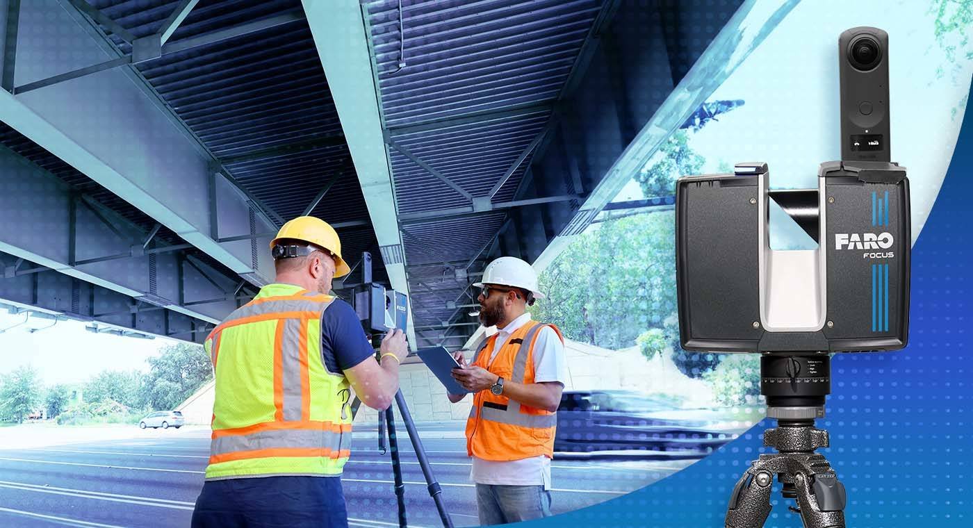
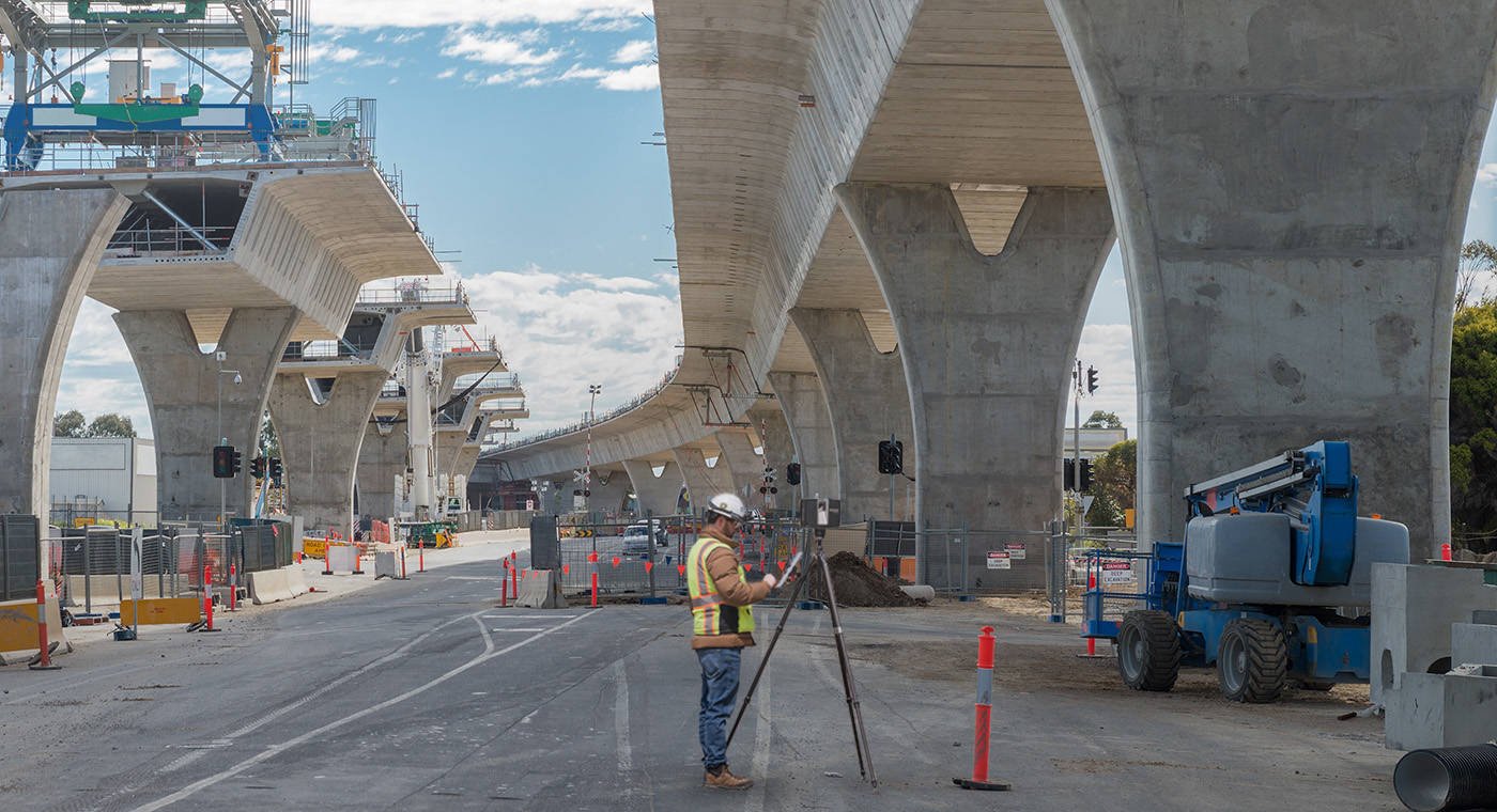
Terrestrial (Ground-Based) LiDAR Scanning
Terrestrial LiDAR is ideal for indoor environments, industrial plants, building facades, and any site where detail and precision take priority. We use phase-based and time-of-flight scanners capable of capturing hundreds of thousands of points per second, producing millimeter-accurate point clouds even in complex, multi-floor environments.
Typical outputs include:
- Registered point cloud data (RCP, E57, LAS formats)
- As-built CAD drawings (2D plans, elevations, sections)
- Scan-to-BIM models (Revit, Navisworks)
- 3D mesh models and photorealistic walkthroughs
UAV/Drone-Based LiDAR Scanning
For large outdoor areas highways, utility corridors, mining sites, agricultural land, or coastal zones drone-mounted LiDAR sensors cover terrain at speed that ground-based surveys simply can’t match. A single drone flight can capture terrain data over several kilometers in a few hours.
Deliverables include:
- Digital Elevation Models (DEMs) and Digital Terrain Models (DTMs)
- Contour maps
- Classified point clouds (vegetation, ground, structures)
- Volumetric calculations
Mobile LiDAR Scanning
When you need to survey roads, railways, or long linear infrastructure, mobile LiDAR mounted on a vehicle gives you rapid data collection without lane closures or major site disruptions. We deliver accurate corridor mapping, road-surface models, and utility mapping at project scale.
Scan-to-BIM Services
One of the most in-demand applications of 3D LiDAR scanning today is Scan-to-BIM converting a point cloud directly into a parametric BIM model. Shayona Tech processes raw scan data into fully structured LOD 200, 300, or 400 Revit models, tailored to the detail requirements of your architecture, engineering, or construction project.
Industries We Serve
Construction and Architecture
Architects and engineers rely on as-built documentation that is actually accurate. Our 3D scan with LiDAR replaces traditional tape measurements and manual drawings with verified, millimeter-precise geometry. This is especially useful for renovation, retrofit, and extension projects where existing drawings are outdated or simply don’t exist.
Oil, Gas, and Industrial Facilities
Plant as-built modeling, clash detection, and piping system documentation are among the most demanding scanning applications. LiDAR handles confined spaces, elevated structures, and complex pipe runs without requiring a shutdown or putting field staff at unnecessary risk.
Mining and Earthworks
Oil, Gas, and Industrial Facilities
Volume calculations for stockpiles, cut-and-fill analysis, deformation monitoring, and underground tunnel mapping all benefit from the dense data a LiDAR scan delivers. Replace manual surveys with repeatable, objective measurements.
Heritage and Cultural Preservation
From Mughal-era monuments to colonial-era buildings, India’s architectural heritage is irreplaceable. LiDAR scanning allows accurate digital preservation, virtual reconstruction, and condition monitoring without any physical contact with fragile structures.
Smart Cities and Infrastructure
Urban planning, traffic corridor analysis, utility mapping, and digital twin development for smart city initiatives increasingly depend on accurate, up-to-date spatial data. Our UAV and mobile LiDAR solutions support large-scale infrastructure documentation across India.
Power and Utilities
Transmission line corridor surveys, substation documentation, and ROW (right-of-way) mapping are faster, safer, and more accurate with LiDAR. We deliver data that supports both design and ongoing asset management.
Why Choose Shayona Tech for 3D LiDAR Scanning Services?
There are plenty of vendors who will hand you a raw point cloud. What sets Shayona Tech apart is what happens after the scan.
Technical depth. Our team combines field scanning expertise with in-house processing capabilities. We handle registration, classification, noise filtering, and model generation so you receive a clean, usable deliverable, not just raw data.
Turnaround that fits your schedule. We understand that project timelines don’t wait. Our processing pipeline is built to get quality outputs to clients without unnecessary delays.
India-wide coverage. Whether your site is in Mumbai, Chennai, Delhi, Hyderabad, or a more remote location, our teams are equipped to mobilize and deliver.
Format flexibility. We deliver in the format your workflow actually requires Revit, AutoCAD, ArcGIS, ReCap, Leica Cyclone, and more. No additional conversion steps on your side.
Transparent communication. From initial site assessment to final delivery, we keep you informed. You know what data you’re getting, what format it’s in, and when it arrives.
If you’re looking for the best 3D LiDAR scanning services in India, Shayona Tech is built to deliver on that standard.
Our Process: From Site to Deliverable
Step 1 — Project Scoping
We start with a conversation. What do you need the data for? What software will you use it in? What level of detail do you require? Understanding your end goal helps us choose the right scanning method and configure the right deliverables.
Step 2 — Site Survey and Mobilization
Our field team assesses the site conditions, identifies scan positions, and plans the data capture strategy. For drone missions, we handle all necessary DGCA compliance and airspace coordination.
Step 3 — Data Capture
Using calibrated, high-accuracy LiDAR hardware, we capture the site. Scan positions are carefully selected for maximum coverage and overlap to ensure a complete, gap-free point cloud.
Step 4 — Registration and Processing
Raw scan data is registered in our processing environment, aligned using targets or natural features, and quality-checked for completeness and accuracy before any modeling work begins.
Step 5 — Deliverable Generation
Depending on project requirements, we produce point clouds, CAD drawings, BIM models, DEMs, contour maps, or photorealistic 3D models. Every deliverable goes through internal QA before client handoff.
Step 6 — Delivery and Support
We deliver your files in agreed formats and walk you through the data. If questions come up post-delivery, we’re available.
Applications of 3D LiDAR Scanning Across Project Types
- Facility management: Accurate as-built records for ongoing maintenance planning
- Reverse engineering: Capturing complex geometry for manufacturing or component replication
- Structural assessment: Deformation monitoring and condition surveys on bridges, dams, and buildings
- Digital twins: Feeding spatial data into real-time facility simulation models
- Accident reconstruction and forensics: Precise spatial documentation for legal and insurance purposes
- Environmental monitoring: Terrain change detection, erosion analysis, flood modelling
- Film and entertainment: Set scanning and virtual production environments
LiDAR vs. Traditional Survey Methods
Factor
- Data density
- Time on site
- Accuracy
- Coverage of complex geometry
- Safety (hazardous areas)
- Deliverable formats
Traditional Survey
- Low
- Long
- Variable
- Limited
- Personnel at risk
- Drawings, notes
LiDAR 3D Scanning
- Extremely high (millions of points)
- Fast — often hours vs. days
- Consistent ±2–5mm
- Comprehensive
- Non-contact, remote capture
- Point cloud, BIM, CAD, DEM, mesh
| Factor | Traditional Survey | LiDAR 3D Scanning |
|---|---|---|
| Data density | ✔Low | ✔Extremely high (millions of points) |
| Time on site | ✔Long | ✔Fast — often hours vs. days |
| Accuracy | ✔Variable | ✔Consistent ±2–5mm |
| Coverage of complex geometry | ✔Limited | ✔Comprehensive |
| Safety (hazardous areas) | ✔Personnel at risk | ✔Non-contact, remote capture |
| Deliverable formats | ✔Drawings, notes | ✔Point cloud, BIM, CAD, DEM, mesh |
DRONE/UAV SURVEY
SHAYONA MANAGEMENT SERVICES PVT LTD (SMSPL) is a prominent and innovative provider of Drone/Unmanned Aerial Vehicle (UAV) services, distinguishing itself in the rapidly evolving field of aerial technology. With a strong foundation in cutting-edge drone technologies and a commitment to delivering exceptional solutions, SMSPL has established itself as a leader in the UAV industry.
Besides this, by integrating a LiDAR sensor onto a drone and utilizing RTK-enhanced GNSS positioning, that ensures centimetre-level accuracy in data collection. It captures detailed elevation information, structures, vegetation, and other features with unmatched precision, while RTK corrections in real-time eliminate positioning errors caused by environmental factors and satellite signal disruptions.
As a dedicated drone services provider, SMSPL offers a wide array of specialized aerial solutions to cater to various industries and sectors. Their expertise extends across fields such as:
Aerial Photography and Videography: Our advanced UAV fleet is equipped with high-resolution cameras and state-of-the-art stabilization systems, allowing them to capture stunning aerial photographs and videos. They excel in producing captivating imagery for industries such as real estate, marketing, tourism, and entertainment.
Photogrammetry Survey: We specialize in capturing high-resolution aerial imagery and transforming it into accurate 3D models, topographic maps, and detailed surveys. Our state-of-the-art drones equipped with advanced cameras and sensors ensure unparalleled data acquisition, enabling industries such as heritage preservation, construction, agriculture, urban planning, and environmental monitoring to make informed decisions with confidence.
Infrastructure Inspection: Our UAV services are pivotal in inspecting critical infrastructure such as power lines, pipelines, bridges, and towers. By conducting aerial inspections, they help detect potential issues, assess structural integrity, and ensure the safety and reliability of vital infrastructure.
Surveying and Mapping: Leveraging cutting-edge Geographic Information System (GIS) technologies, we generate accurate 3D maps and topographic models through aerial surveying. This aids in urban planning, construction site monitoring, and land development projects. Besides this generation of precise DEM, DTM, and DSM datasets, translating real-world landscapes into high-resolution TIFF deliverables for enhanced topographic insights and actionable geospatial analysis.
Industrial Applications: Industries such as mining, oil and gas, and manufacturing benefit from our UAV services for tasks like asset inspection, volumetric measurements, and site monitoring, enhancing operational efficiency and safety.
Data Analytics and Reporting: We provides comprehensive data analysis and reporting services using the information gathered by their drones. This empowers clients with actionable insights and informed decision-making.
CAD TO BIM
SMSPL is a leading provider of CAD to BIM (Computer-Aided Design to Building Information Modelling) services, offering innovative solutions to transform traditional design processes into efficient, intelligent, and data-rich workflows. With a focus on enhancing the construction and architecture industries, XYZ Company specializes in seamlessly converting 2D CAD drawings into detailed and comprehensive 3D BIM models.
Through its CAD to BIM services, we facilitate the transition from static design representations to dynamic, information-rich models that enable collaboration, analysis, and optimization throughout the project lifecycle. Our team of skilled professionals employs advanced software and techniques to accurately translate CAD designs into BIM, incorporating elements such as geometry, materials, spatial relationships, and metadata.
Our commitment to accuracy, precision, and attention to detail ensures that clients receive BIM models that accurately reflect the original CAD designs while introducing the benefits of parametric modelling, data integration, clash detection, and simulation. By harnessing the power of CAD to BIM conversion, we empower architects, engineers, contractors, and stakeholders to make informed decisions, streamline workflows, and enhance the overall project outcome.
SCAN TO BIM
Shayona Management Services Pvt Ltd (SMSPL) is a leading "Scan to BIM modelling" service provider, specializing in transforming physical buildings, structures, and environments into precise and detailed Building Information Models (BIM). Our expertise lies in using cutting-edge technologies such as 3D laser scanning, reality capture, and point cloud processing to capture accurate data from existing structures and convert them into intelligent BIM models.
SMSPL plays a crucial role in the construction and architectural industries by enabling seamless integration of real-world data into the digital design and construction process. They work with a wide range of projects, including residential buildings, commercial complexes, infrastructure, heritage sites, and industrial facilities.
Our team of skilled BIM experts and technicians meticulously process the captured data to create highly detailed and parametric BIM models. These models contain valuable information such as dimensions, materials, systems, and spatial relationships, providing a comprehensive and collaborative platform for architects, engineers, contractors, and other stakeholders to work on a project.
By utilizing state-of-the-art BIM software, SMSPL ensures that their "Scan to BIM modelling" services produce models that are not only visually accurate but also information-rich, facilitating efficient planning, design validation, clash detection, and coordination throughout the project lifecycle.
Furthermore, SMSPL emphasizes collaboration and open communication with their clients, understanding the unique requirements of each project and tailoring their services accordingly. They are committed to delivering projects on time and within budget, enabling clients to make informed decisions, reduce risks, and enhance project outcomes.
With a reputation for excellence in "Scan to BIM modelling" services, SMSPL has become a trusted partner for architecture firms, construction companies, and real estate developers seeking to leverage the power of BIM technology to optimize their projects' design, construction, and maintenance processes. Their dedication to accuracy, innovation, and customer satisfaction makes them a reliable and sought-after service provider in the BIM industry.
REVERSE ENGINEERING
Reverse engineering using LiDAR scanning involves the use of Light Detection and Ranging (LiDAR) technology to capture precise and detailed 3D measurements of an object or environment. LiDAR sensors emit laser pulses and measure the time it takes for the light to bounce back after hitting a surface, creating a point cloud representation of the surroundings.
In the context of reverse engineering, LiDAR scanning allows engineers and designers to analyse and recreate the physical structure of an object or area with exceptional accuracy.
LiDAR-based reverse engineering finds applications in various fields, including architecture, archaeology, product design, urban planning, and civil engineering. It provides a fast and accurate way to recreate physical objects in digital form, enabling innovation, preservation, and enhancement of existing designs.
AS-BUILT MODELLING
SMSPL is a leading "As-built Modelling" service provider, specializing in creating accurate and detailed digital representations of existing structures and environments. Their expertise lies in capturing real-world data through various surveying/LiDAR techniques and transforming it into high-quality 3D models, enabling clients to have a comprehensive record of the as-built condition of their projects.
As an "As-built Modelling" service provider, SMSPL caters to a wide range of industries, including architecture, engineering, construction, facility management, and more. They offer a valuable solution for projects that require precise documentation of existing conditions, such as renovations, refurbishments, retrofitting, and historical preservation.
HERITAGE CONSERVATION
As a Heritage Conservation Service Provider specializing in LiDAR Scanning, we are dedicated to the preservation, documentation, and restoration of our cultural heritage using cutting-edge technology. Our LiDAR scanning services offer a comprehensive and non-invasive approach to capturing historical sites, cultural landmarks, and architectural wonders with unparalleled precision and accuracy.
Key points to highlight in describing our Heritage Conservation Service Provider using LiDAR Scanning:
Advanced LiDAR Technology: We leverage state-of-the-art LiDAR (Light Detection and Ranging) technology, which utilizes laser pulses to measure distances and create highly detailed 3D point clouds of heritage sites. This non-contact, non-destructive technique ensures that the integrity of historical structures is preserved while obtaining the most accurate data possible.
Comprehensive Documentation: Our LiDAR scanning services encompass the meticulous documentation of heritage sites. By capturing intricate details in 3D models and point clouds, we create a digital archive that serves as a valuable resource for research, conservation planning, and public education.
Precise Data Acquisition: Through LiDAR scanning, we obtain precise data, including architectural elements, surface features, and spatial relationships. This information is critical for understanding the historical significance of the site and forms the basis for preservation and restoration efforts.
Non-Invasive Preservation: Our LiDAR scanning approach is non-invasive, ensuring that the heritage sites remain undisturbed during the data collection process. This ethical and sustainable approach aligns with best practices in heritage conservation, safeguarding these treasures for future generations.
Monitoring and Change Detection: Beyond initial documentation, our services extend to ongoing monitoring and change detection. By periodically scanning the heritage sites, we can identify and assess any alterations or deterioration, enabling proactive conservation measures.
Restoration Support: Our LiDAR scanning data plays a crucial role in supporting restoration efforts. The detailed 3D models aid architects, historians, and conservationists in planning and executing restoration projects that respect the original architectural integrity.
Collaboration and Expertise: As a Heritage Conservation Service Provider, we prioritize collaboration with clients, archaeologists, historians, and other stakeholders. Our team of LiDAR experts brings extensive knowledge and experience to ensure that the scanning process aligns with the specific conservation goals and requirements of each project.
Compliance and Ethical Considerations: We adhere strictly to all relevant regulations and ethical considerations in heritage conservation. Our practices are designed to minimize any potential impact on the heritage sites while maximizing the accuracy and usefulness of the collected data.
Public Engagement and Education: The 3D models and visualizations resulting from our LiDAR scanning can be used for public engagement and educational purposes. By sharing the digital replicas of heritage sites, we promote awareness and appreciation of our cultural history.
INFRASTRUCTURE ASSESSMENT
Infrastructure Assessment using LiDAR scanning involves the use of Light Detection and Ranging (LiDAR) technology to evaluate and analyse various types of infrastructure, such as roads, bridges, buildings, power lines, and more. LiDAR is a remote sensing technology that uses laser pulses to measure distances and create high-resolution 3D maps of the surrounding environment.
We as Shayona Management Services Pvt Ltd, offers Infrastructure Assessment with LiDAR conducts surveys and data collection using specialized LiDAR-equipped sensors, typically mounted on drones, aircraft, or vehicles. These LiDAR systems emit laser beams that bounce off the infrastructure’s surfaces and return to the sensor, enabling the generation of detailed point cloud data.
The point cloud data is then processed and transformed into accurate and comprehensive 3D models of the infrastructure. This information can be used for various purposes, including:
Asset Management: Providing insights into the condition and health of infrastructure assets to aid in maintenance and repair planning.
Engineering Design: Assisting engineers in planning new infrastructure projects and evaluating potential challenges and risks.
Environmental Analysis: Assessing the impact of infrastructure on the surrounding environment, such as waterways and natural habitats.
Urban Planning: Supporting city planners in making informed decisions about future development and infrastructure expansion.
Using LiDAR as a service provider offers several advantages, including faster data collection, higher accuracy, and reduced costs compared to traditional surveying methods. It enables organizations and governments to make data-driven decisions, enhance public safety, and improve the overall efficiency and sustainability of their infrastructure.
AR-VR & MR-XR EXPERINCE
At Shayona Management Services Pvt Ltd, we are at the forefront of innovation, harnessing the power of Augmented Reality (AR), Virtual Reality (VR), Mixed Reality (MR), and Extended Reality (XR) to transform the way businesses operate, communicate, and engage with their audiences.
Our team of skilled engineers, designers, and developers are experts in the latest AR-VR and MR-XR technologies, ensuring we deliver state-of-the-art solutions to our clients.
We understand that every business is unique. That’s why we tailor our AR-VR and MR-XR services to meet your specific needs, whether it’s immersive training simulations, interactive marketing experiences, or virtual product prototypes. From conceptualization and design to development and deployment, we offer end-to-end services, ensuring a seamless and hassle-free experience for our clients.
Our Services:
Augmented Reality (AR): SMSPL leverages AR to enhance the real world with digital overlays, enabling businesses to provide interactive user experiences, remote assistance, and captivating marketing campaigns.
Virtual Reality (VR): Immerse your audience in a completely virtual environment with our VR solutions. Whether it’s for training, gaming, promotion or virtual tours, we create VR experiences that leave a lasting impact.
Mixed Reality (MR): Our MR solutions merge the physical and digital worlds, allowing for dynamic interactions. This technology is ideal for remote collaboration, real-time data visualization, and advanced training simulations.
Extended Reality (XR): XR combines AR, VR, and MR to offer the most versatile and immersive experiences. We help businesses leverage XR for a wide range of applications, from healthcare to architecture.
We stay ahead of the curve by constantly exploring new technologies and methodologies to ensure our clients benefit from the latest advancements. With a proven track record of successful AR-VR and MR-XR projects across various industries, SMSPL Company has the expertise to bring one’s vision to life. Client goals and satisfaction are our top priorities. We work closely with them to understand their objectives and deliver solutions that exceed their expectations.
VIRTUAL EVENT WITH 360 DEGREE COVERAGE
SMSPL is a premier service provider specializing in delivering unparalleled "Virtual Events with 360 Degree Coverage." With a proven track record of excellence, SMSPL transforms ordinary online gatherings into immersive and dynamic experiences that captivate participants from all corners of the globe.
We have expertise in 360-degree content creation. This involves capturing environments, events, and objects from all angles, providing a holistic view that allows viewers to explore and experience every facet of the subject matter. By leveraging advanced technologies and creative techniques, SMSPL crafts visually stunning and interactive content that captures attention and leaves a lasting impression.
Additionally, SMSPL specializes in creating Cave virtual immersive experiences that transport users into dynamic digital environments. Whether it's a virtual tour of a real-world location, a simulated training scenario, or an interactive product showcase, our virtual immersive experiences enable users to engage with content on a deeply immersive level. This technology-driven approach enhances engagement, education, and entertainment, enabling businesses to forge stronger connections with their target audiences.
In a rapidly evolving digital landscape, we stand out as a visionary leader, constantly pushing the boundaries of what's possible in content creation and virtual experiences. With a commitment to quality, creativity, and technological excellence, our Company is shaping the future of how audiences interact with and experience digital content.
Get a Quote for 3D LiDAR Scanning Services in India
Tell us about your project and we’ll get back to you with a clear scope and competitive pricing.
LiDAR 3D Scanning Services
Modern terrestrial LiDAR scanners used in professional projects typically achieve accuracy in the range of 2 to 5 millimeters under standard conditions. For large-scale drone surveys, accuracy depends on flight altitude and ground control point density but generally stays within 5 to 10 centimeters. Shayona Tech performs post-processing QA to ensure the delivered data meets project-specific accuracy requirements.
It depends on site size and complexity. A typical industrial facility or building floor can be scanned in a single day. Data processing, registration, and model delivery usually takes between 3 to 7 working days depending on scope. Large infrastructure or multi-site projects are scoped and scheduled individually, and we provide clear timelines before work begins.
We support a wide range of output formats based on your workflow. These include LAS, E57, and RCP for point clouds; RVT (Revit) and NWD (Navisworks) for BIM; DWG and DXF for CAD; GeoTIFF and SHP for GIS outputs; and OBJ or FBX for 3D mesh models. If you use a platform not listed here, get in touch we likely support it.
Yes. LiDAR is a non-contact technology. The scanner fires laser pulses and passively captures the return signal it doesn’t require physical interaction with any surface. This makes it well-suited to operating chemical plants, energized substations, refineries, and other environments where bringing personnel close to equipment poses a safety risk. Our team also follows all relevant site safety protocols.
Scan-to-BIM is the process of converting a LiDAR point cloud into a structured BIM model inside platforms like Revit. After scanning a building or facility, we use the registered point cloud as a reference to create parametric 3D elements walls, columns, beams, pipes, and so on at the level of detail (LOD) your project requires. The result is an accurate as-built model you can use for design coordination, renovation planning, or facility management.